CAROLYN’S COMPOSITIONS
LAUREL HILL IN FAYETTE COUNTY, PENNSYLVANIA
January 2013 found me resting from the demands of 2012, pushing to catch up on that year’s leftover tasks. I felt guilty for not returning to work on my novel during the month, but I did accomplish much other work.
The last day in January I was finally motivated to review the novel chapter relating the trek of a large number of French émigrés from Alexandria, Virginia to Gallipolis, Ohio, to be the first settlers of this western frontier town.
These émigrés had purchased land from an American land grant company in Paris, Compagnie du Scioto. It was an outgrowth of the Scioto Associates, a group of Revolutionary War officers and others who had signed an option with the Ohio Company (1787) to purchase a large tract of wilderness land in Ohio, a part of the Northwest Territory. Obligated to sell a percentage of the land in Europe they sent an agent, Joel Barlow, to France, to sell that portion of the land there.
I chose to return to the novel to review this material for two reasons
I want to send it out for a review of the historical material,
I want to prepare a power point presentation to use for a special Beanery Writers Group meeting.
There were several places in the chapter where research was necessary to clarify the material. One was CROSSING LAUREL HILL: INFORMATION NEEDED.
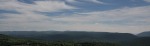
A view of the rolling hills in the Laurel Ridge
Although I’d lived in Connellsville in Fayette County between 1995 and 2003, I’d yet to decipher the geography aspects of this part of the Frenchmen’s trek that took place somewhere north of Uniontown.
I typed Laurel Hill into the Internet search engine. The first result I opened revealed why I’d had so much difficulty sorting out the material in the past. It stated that Laurel Hill, also known as Laurel Ridge or Laurel Mountain, is a 70-mile (110 km) long mountain in Pennsylvania’s Allegheny Mountains.*
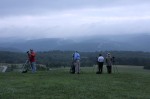
Westmoreland Photography Society members photograph Laurel Ridge from Kentuck Knob in PA
Wait a minute…isn’t the 70-mile (110 km) long mountain in Pennsylvania’s Allegheny Mountains the Laurel Ridge? Why do they refer to it as Laurel Hill?
Furthermore, I live in the western foothill of Laurel Mountain. I never considered it to be Laurel Hill. After all, the Laurel Hill the émigrés descended led to an area north of Beesontown (that era’s name for Uniontown) where the Braddock Road part of the Nemacolin Indian Trail separated off the trail to head northwest to the future Pittsburgh (the trail itself continued west to Redstone, that era’s name for Brownsville).
The article continues: Laurel Hill is flanked on its north end by the Conemaugh Gorge and on its south end by the Youghiogheny Gorge… The towns of Johnstown and Latrobe are located on its northern end, while Confluence and Farmington are located towards its southern end.*
The Conemaugh Gorge and Johnstown are located northeast of my community of Laurel Mountain Borough, an hour’s drive from the Youghiogheny Gorge. The Youghiogheny Gorge and the communities of Confluence and Farmington are southeast of Connellsville. The description agrees with the seventy miles length of what the site describes as Laurel Hill. It definitely doesn’t describe a particular hill north of Uniontown, a hill I’d heard about but never before considered significant to my life.
I now knew the source of my confusion: Laurel Ridge is referenced as Laurel Hill. The Laurel Hill the émigrés descended, then, could be described as being on Laurel Hill.
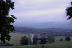
A road, viewed from Kentuck Knob, leads to Laurel Ridge
A second site offered more helpful information: Laurel Hill is a populated place located in Fayette County… The elevation is 965 feet.** Laurel Ridge (Laurel Hill???) is is flanked by Negro Mountain to its east and Chestnut Ridge to its west.*
I know where Negro Mountain is.
 More information came as I read about another familiar landmark, Jumonville: Jumonville, PA is a village in North Union Township, PA that is located on Chestnut Ridge in Fayette County, PA…Jumonville, a Christian Camp and Retreat Center located at Jumonville, PA along the crest of Chestnut Ridge’s Dunbar Knob (elevation 2,480 feet), is famous for its The Great Cross Of Christ, a 60 foot tall steel white cross that is visible throughout the Uniontown, PA area.
All this information allows me to write the part of my chapter on the Laurel Hill part of the émigrés trek to Redstone. So I retreat from this post to do so, and hope the material here is of benefit to others who might also be confused about the location of Laurel Hill.
~~~~~~~~~~~~
ADDITIONAL READING:
Should Negro Mountain’s (in Pa/Md) Name Be Changed?
Should Big Mt. Savage (PA/MD) Be Renamed?
FEBRUARY DAYS TO CELEBRATE
THE OHIO COMPANY AND SCIOTO ASSOCIATES LAND PURCHASES (Novel #2)
Compagnie du Scioto Meeting at Café le Procope: Novel #3A
Compagnie du Scioto Meeting at Cafe le Procope (Novel #3B)
SOURCES

Laurel Hill in Fayette County, Pennsylvania
Tags: All, All posts, COMMENTARY, Contemplation, Latest post, Laurel Hill (PA), Laurel Ridge in Appalachia, Misc., Miscellaneous, postaday2013, Reflections, Thoughts
CAROLYN’S COMPOSITIONS
LAUREL HILL IN FAYETTE COUNTY, PENNSYLVANIA
January 2013 found me resting from the demands of 2012, pushing to catch up on that year’s leftover tasks. I felt guilty for not returning to work on my novel during the month, but I did accomplish much other work.
The last day in January I was finally motivated to review the novel chapter relating the trek of a large number of French émigrés from Alexandria, Virginia to Gallipolis, Ohio, to be the first settlers of this western frontier town.
These émigrés had purchased land from an American land grant company in Paris, Compagnie du Scioto. It was an outgrowth of the Scioto Associates, a group of Revolutionary War officers and others who had signed an option with the Ohio Company (1787) to purchase a large tract of wilderness land in Ohio, a part of the Northwest Territory. Obligated to sell a percentage of the land in Europe they sent an agent, Joel Barlow, to France, to sell that portion of the land there.
I chose to return to the novel to review this material for two reasons
I want to send it out for a review of the historical material,
I want to prepare a power point presentation to use for a special Beanery Writers Group meeting.
There were several places in the chapter where research was necessary to clarify the material. One was CROSSING LAUREL HILL: INFORMATION NEEDED.
A view of the rolling hills in the Laurel Ridge
Although I’d lived in Connellsville in Fayette County between 1995 and 2003, I’d yet to decipher the geography aspects of this part of the Frenchmen’s trek that took place somewhere north of Uniontown.
I typed Laurel Hill into the Internet search engine. The first result I opened revealed why I’d had so much difficulty sorting out the material in the past. It stated that Laurel Hill, also known as Laurel Ridge or Laurel Mountain, is a 70-mile (110 km) long mountain in Pennsylvania’s Allegheny Mountains.*
Westmoreland Photography Society members photograph Laurel Ridge from Kentuck Knob in PA
Wait a minute…isn’t the 70-mile (110 km) long mountain in Pennsylvania’s Allegheny Mountains the Laurel Ridge? Why do they refer to it as Laurel Hill?
Furthermore, I live in the western foothill of Laurel Mountain. I never considered it to be Laurel Hill. After all, the Laurel Hill the émigrés descended led to an area north of Beesontown (that era’s name for Uniontown) where the Braddock Road part of the Nemacolin Indian Trail separated off the trail to head northwest to the future Pittsburgh (the trail itself continued west to Redstone, that era’s name for Brownsville).
The article continues: Laurel Hill is flanked on its north end by the Conemaugh Gorge and on its south end by the Youghiogheny Gorge… The towns of Johnstown and Latrobe are located on its northern end, while Confluence and Farmington are located towards its southern end.*
The Conemaugh Gorge and Johnstown are located northeast of my community of Laurel Mountain Borough, an hour’s drive from the Youghiogheny Gorge. The Youghiogheny Gorge and the communities of Confluence and Farmington are southeast of Connellsville. The description agrees with the seventy miles length of what the site describes as Laurel Hill. It definitely doesn’t describe a particular hill north of Uniontown, a hill I’d heard about but never before considered significant to my life.
I now knew the source of my confusion: Laurel Ridge is referenced as Laurel Hill. The Laurel Hill the émigrés descended, then, could be described as being on Laurel Hill.
A road, viewed from Kentuck Knob, leads to Laurel Ridge
A second site offered more helpful information: Laurel Hill is a populated place located in Fayette County… The elevation is 965 feet.** Laurel Ridge (Laurel Hill???) is is flanked by Negro Mountain to its east and Chestnut Ridge to its west.*
I know where Negro Mountain is.
All this information allows me to write the part of my chapter on the Laurel Hill part of the émigrés trek to Redstone. So I retreat from this post to do so, and hope the material here is of benefit to others who might also be confused about the location of Laurel Hill.
~~~~~~~~~~~~
ADDITIONAL READING:
Should Negro Mountain’s (in Pa/Md) Name Be Changed?
Should Big Mt. Savage (PA/MD) Be Renamed?
FEBRUARY DAYS TO CELEBRATE
THE OHIO COMPANY AND SCIOTO ASSOCIATES LAND PURCHASES (Novel #2)
Compagnie du Scioto Meeting at Café le Procope: Novel #3A
Compagnie du Scioto Meeting at Cafe le Procope (Novel #3B)
SOURCES
Share this:
Related